

Shedding light on the earthquake situation
Researchers from the Swiss Seismological Service have worked together with the Seismology and Geodynamics group at ETH Zurich and with local support in Bhutan to install a temporary seismological network. They plan to use the network to close a gap in geophysical research of the Himalayas.
Switzerland has a strong tradition of geological research in Bhutan. The famous geologist Augusto Gansser compiled the first geological map of the Kingdom, published in 1983. In November 2010, researchers from ETH Zurich and the University of Montpellier carried out extensive measurements of the Earth’s gravity field in Nepal and Bhutan. This data made it possible for the first time to create a model on how the Indian and Asian continental plates collide beneath the Eastern Himalayas. Between January 7th and February 3rd 2013, the ETH Zurich team collaborated with seismologists from Bhutan to install a temporary seismic network there. In an interview with ETH Life, György Hetényi, head of the project and senior research associate at the Swiss Seismological Service (SED) of ETH, explains the objectives of and the background to the project.
Mr. Hetényi, you have just come back from
Bhutan with your team. How many seismometers did you install during the
fieldwork?
After the
project funding was approved by SNF last September, we prepared the instruments
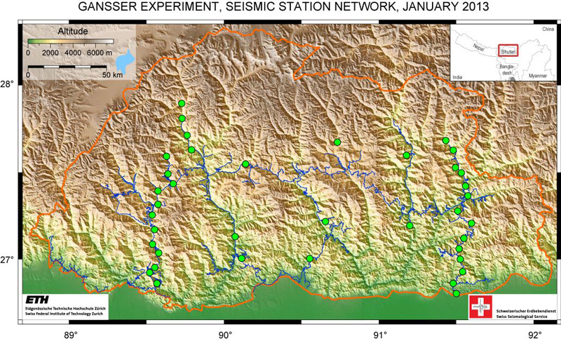
at ETH Zurich over the autumn and in November and December we sent 38
seismometers to Bhutan by airplane. We have now installed all instruments.
Bhutan is about as big as Switzerland. We aligned the seismometers in two lines
running from North to South with 14 and 16 stations; eight stations are located
between these lines.
In geophysical terms, Bhutan is like a blank spot
on the map. There are scarcely any seismological measurements of this region to
date. You plan to use the temporary network to bridge this gap?
Exactly. We
want to get an insight into the structure of the Earth’s crust and get an idea
on how the mountains’ root underneath the surface looks like. The Earth’s crust
in India, to the South, has a normal thickness of ca. 35 kilometres. In Tibet,
to the North, the crust is twice as thick. It is not known what the geometry of
the thickening crust looks like in between, i.e., where Bhutan is. And that's
what we are interested in. We plan to find out whether the differences in crustal
thickness give indications for major thrust faults. Possible movements could
cause very large earthquakes there. We image these structures using seismic
records with which we can also help assessing earthquake hazard.
Our second
objective, which is equally important, is to measure and describe Bhutan’s
day-to-day earthquake activity. The people living there notice smaller and
medium-sized tremors on a regular basis, but we do not know how many
earthquakes there are, how strong they are and where in Bhutan do they take
place.
Unlike in other regions of the Himalayas, there
have been no significant earthquakes in Bhutan in the past 120 years. What is
your explanation for this?
This is the
timescale we usually talk about because that’s how long seismometers exist and have
been recording earthquakes. In that time, four strong earthquakes with a
magnitude 8 or above have been registered in the Himalayas, but none in Bhutan.
Nor do historical sources provide any clear indication of strong earthquakes in
Bhutan. Statistically, however, major earthquakes can take place every couple
of centuries or millennia in a region, which is why the fact that there have
been no larger earthquakes in recent times does not necessarily mean that the hazard
is low. We are trying to better understand the earthquake activity in Bhutan
with the help of the network we installed. In western Nepal, there is a similar
gap in the occurrence of major earthquakes. At the moment it seems that there
are regions in the Himalayas that are less susceptible to major quakes.
Do you have any explanation at present for this
exceptional situation in Bhutan?
We have two
general explanations as to why major earthquakes have not been recorded yet.
One is that stresses have been accumulating over years and centuries along the
large thrusts where earthquakes can take place and that one day this will
result in a huge earthquake. Longer periods without major tremors thus do not
mean that it is not possible to have major earthquakes in this region. The
second and for Bhutan the better scenario is that the plates are very slowly
but continuously sliding, creeping along each other. As a result, no major stresses
are accumulating at those locations. At the moment we do not yet have any idea
what the situation in Bhutan is.
Don’t the field observations give any
indication of earlier earthquakes?
Our
colleagues from Montpellier are currently searching through the deposits of the
past millennia at the foot of the Himalayas to determine whether there are
abrupt changes on the surface or larger disruptions along geological strata,
with several metres offset. These would indicate strong earthquakes of which we
could determine the date.
Does the pioneering work carried out by the
Swiss Augusto Gansser form the basis for your fieldwork today?
Gansser
once charted the geology of Bhutan, and our project is
named after him. His geological map shows us how the mountains in Bhutan
developed over millions of years. It is very important for us because it shows
the long-term development of the region and gives us all of the geological
information about the surface and a few hundred metres deep. With our seismological
study, we are now going to image the structures down to 70 to 90 kilometres
depth. This allows us to examine the deep structure of the crust. Both dataset
together will help us to understand the development of the Himalayas.
For how long will you operate the seismic
network?
The plan is
that the network will carry out measurements until the spring of 2014, so for
approximately 16 months. Temporary measurements have to run for at least a year
so that we can get meaningful data. After that the mobile instruments will be
used for other projects.
Wouldn’t it be important for Bhutan to have a
permanent network?
That’s an
important point. We are currently discussing the options for a permanent
network with the Department for Geology and Mines and the Department for
Disaster Management. The permanent network we have in Switzerland is a very
good example. If the discussions go well, we will try to obtain funding
together with other countries so that we could install a permanent network of
12 or 15 stations in a couple of years. Bhutan currently does not have the
necessary financial means and expertise to establish the network without foreign
assistance.
How do you get the collected data?
At the
moment, minicomputers record the data for each station locally. We will travel
to Bhutan three times during the measurement period to check that everything is
in order and to copy the data. If we have the time in April and the necessary
instruments, we will install a communication system at some stations. This
would allow us to receive the data through wireless or via satellite.
What is the working relationship like with
scientists from Bhutan?
The experts
in Bhutan help us a lot. As already in the past years, they provide extensive
assistance to us and they understand very rapidly and well what we need. We
have a friendly relationship, right up to the heads of the Geology and Disaster
Management departments. This results in a valuable and lasting working
relationship that I appreciate very much.
What were the biggest obstacles in the project?
Getting in touch with the right people in Bhutan and securing funding.
Bhutan was a closed country that only gradually started to open up in the
1960s. Even today, if you want to travel there as a tourist, you have to pay 250
USD per day visa fee. It was also difficult to organize the logistics of our
expedition. We had to send two tons of material by airplane from Zurich to
Bhutan, and that was a real challenge. You can only get into the country with
one airline, and that airline has only one type of large aircraft. We had to
pack smaller boxes so that they fit in the aircraft. And although the Bhutanese
geologists were very welcoming of the collaboration, the project had to be
first examined and approved by the «Gross National Happiness Commission».
How long did it take from the preparation to
the work in the field?
It took a
year from the first contact until starting the work on site. That’s not very
long, but for us it was a new experience. It was also a challenge to get all the
material we needed and wanted to buy there. All consumer goods that are sold in
Bhutan come from India and the road conditions for transportation are often
difficult. For example, the batteries for the stations arrived later than
planned, and we were always unsure whether everything would work out. But in
the end there were no major delays. We are really very happy that there were no
problematic situations or accidents.
You are also working with scientists from
France and the USA on this project...
...that’s
right, in 2010 we carried out gravity measurements with our colleagues from
Montpellier. We are now doing the seismology, and are also getting help from a
colleague from Montpellier. Additionally, as I mentioned, scientists from
France are examining the geological layers for traces of past large
earthquakes. They are also planning to set up a GPS network. We are working
hand in hand, but each university has the lead for a certain aspect. We are
receiving support from the USA from an expert who has already installed seismological
stations around the globe and can teach us a lot.
You did your master’s project and PhD dissertation
on the Himalayas. What draws you back there again and again?
That’s a
good question. I really like being in the outdoors. Where I come from, in
Hungary, the mountains are very small (laughs). I am not a climber or a real
fan of very high peaks, but I like to hike and do orienteering races. In the end
I came to this region through my scientific advisors, who were doing research
in the Himalayas and Tibet. Since then I have been fascinated by this topic.
Another thing is that I was very impressed by Buddhism the first time I was in
the Himalayas. I found it very interesting to discover the eastern cultures and
their ways of thinking and to compare those with the European, Judeo-Christian
traditions and ways of living.
About the interviewee
György Hetényi (33 years old) is a senior research associate at the Swiss Seismological Service and is leading the «GANSSER» project in Bhutan for the Swiss Seismological Service and ETH Zurich. He did his doctorate on the evolution and deformation of the Himalayas and specializes in the geodynamics of the continental lithosphere.


READER COMMENTS